
Defining the election boundaries, such as geopolitical zones, wards and polling units in Nigeria is essential for the conduct of transparent and credible elections. This process is overseen by the Independent National Electoral Commission (INEC), which is responsible for conducting all federal, state, and local government elections in the country. Here’s an overview of each term and how the process works:
Election boundaries refer to the geographic demarcations that divide the country into different electoral constituencies, wards, and polling units. These boundaries determine the areas from which representatives, such as members of the National Assembly or state legislatures, are elected within a state. The delimitation of election boundaries aims to ensure that each constituency has a relatively equal population size to maintain fairness and representation.
The process of defining election boundaries involves demographic data analysis, public consultations, and consideration of factors such as population distribution, geography, community interests, and administrative convenience. INEC conducts this exercise periodically, especially after each national census or towards each electoral cycle, to ensure equitable representation and adjust the boundaries as necessary. Below is the list of states, local government areas, number of geopolitical zones, wards, and polling units in Nigeria.
The Federal Republic of Nigeria is divided into six geopolitical zones, which is a form of administrative division that groups the country’s states into regions. The six zones were not entirely carved out based on geographic location, but rather states with similar ethnic groups, and/or common political history were classified in the same zone. The zones are used for Nigerian economic, political, and educational resource sharing and distributions. Here are the six geopolitical zones in Nigeria and their states:
A ward is a smaller administrative unit within a local government area (LGA) in Nigeria. Wards are established to bring governance and services closer to the people at the grassroots level. Each LGA is divided into several wards based on factors like population density and geographical considerations.
Wards serve as the basic building blocks for political representation at the local government level. Each ward elects a councillor who represents the interests of the ward at the local government council. Nigeria has 774 local government areas with 8,813 Electoral Wards. Please note that electoral wards in Nigeria are subject to change, with new wards being created by INEC in response to population growth or other factors.
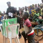
Polling units are the smallest operational units for elections in Nigeria. These units are where voters cast their ballots on election day. They are usually located within or near communities to ensure easy access for voters. The establishment of polling units is crucial for promoting electoral participation and preventing voter disenfranchisement.
INEC is responsible for determining the locations of polling units. These locations are usually public places, such as schools, community centers, or government buildings. The commission considers factors like population density, accessibility, and security when selecting polling unit locations.
As of 2023, the Nigerian electoral system has 119,973 polling units across the country. These polling units are organized into wards, which are further organized into local government areas. You can locate your polling unit by using the Polling Unit Locator Tool on the INEC Portal. All you need to do is Select your State, LGA and Ward; Click “Search” to find your polling unit address.
It’s important to note that the delimitation of election boundaries, establishment of wards, and polling units can sometimes be politically contentious, as it can impact the distribution of political power and representation. INEC strives to carry out these processes in a transparent and impartial manner to ensure fair representation and credibility in the electoral system.
Public consultation and feedback are typically sought to enhance transparency and inclusivity in the delineation of these electoral units. Now you know more about election boundaries, geopolitical zones, wards and polling units in Nigeria are essential for the conduct transparent and credible elections.
We hope this article help?
 Campaigns of Calumny and Propaganda in Nigeria
 Roles of Civil Society Organizations in Nigeria Elections
 Political Campaign Finance Laws in Nigeria
 Including People with Disabilities in Nigerian Politics
 How to Register a Political Party in Nigeria
 10 Democratic Principles You Should Know
 Ethical Standards in Election Campaigns in Nigeria
 The Roles of Journalists in Politics